
New rain season starts this week. Where do SLO County rainfall totals, lake levels stand?
This Thursday, July 1, is the start of the 2021 rainfall year season.
So, what were the rainfall totals throughout the Central Coast for the last rainfall year season, which will end on Wednesday, June 30, before possible thunderstorms produce rain on Thursday, the start of the 2021 rain season?
Cal Poly recorded 13.34 inches of rain, or about 60% of average precipitation.
If not for the late January atmospheric river event that stalled over Cambria and retrograded northward toward Big Sur before moving southward into southern San Luis Obispo and northern Santa Barbara counties, this would have been the driest year on record since 1869 at Cal Poly.
If you removed the moisture from January’s atmospheric river, which produced 7.21 inches of rain over a three-day period at Cal Poly, you would be left with only 6.13 inches for this season. The driest year on record at Cal Poly is 1897, which only saw 7.20 inches of precipitation.
Cal Poly’s Irrigation Training and Research Center maintain the longest continuous rainfall observations for the Central Coast; those records are available online at itrc.org.
Cambria, the epicenter of January’s atmospheric river, recorded 15.87 inches of rain this season and pushed its total to 72% of average, the highest average rainfall throughout the entire Central Coast.
Overall, most Central Coast locations reported between 40% and 60% of average rainfall.
Paso Robles Municipal Airport recorded 6.82 inches of rain this season. It should be at 12.53 inches.
Farther south, the Santa Maria Airport reported 6.96 inches of rain. Much like Paso Robles, it should be near 13 inches at the end of the season.
The Santa Ynez Airport recorded 6.75 inches of rain and the Lompoc Airport 8.73 inches.
Along with the low rainfall amounts, our local lake and reservoir totals are well below average.
Near the border of Monterey and San Luis Obispo counties, Nacimiento Lake is at 23% of capacity, while Lake San Antonio reported 12% of the total capacity.
Lopez Lake is 35% of capacity, Salinas Reservoir near Santa Margarita is at 65%, and Whale Rock Reservoir near Cayucos is 76%.
In Santa Barbara County, Cachuma Reservoir is at 57% capacity, and Gibraltar Reservoir is 10%.
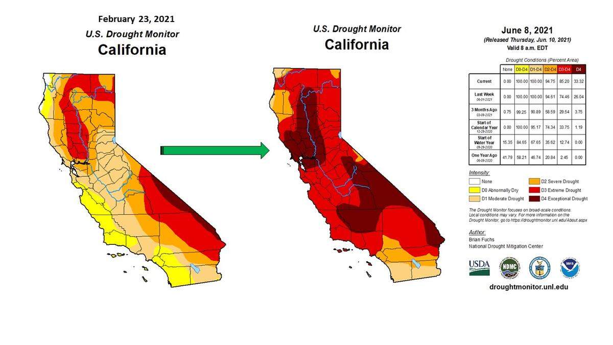
The U.S. Drought Monitor increased the severity of the drought throughout the Central Coast from an Abnormally Dry (D0) classification in late February to an Extreme Drought (D3) level in early June.
In fact, for the first time in the Drought Monitor’s history, more than 90% of the western United States is in drought.
I have been following the drought index for nearly two decades, and I have never seen such a dramatic increase in drought severity over such a short period.
That leads to this question: Why?
The U.S. Drought Monitor says it determines the severity of a drought utilizing the following factors: the “Palmer Drought Severity Index, the Standardized Precipitation Index, and other climatological inputs; the Keech-Byram Drought Index for fire, satellite-based assessments of vegetation health and various indicators of soil moisture; and hydrologic data, particularly in the West, such as the Surface Water Supply Index and snowpack.”
Overall, it was probably many factors coming together at the same time.
First, we experienced the driest back-to-back Februarys in 152 years of rainfall records at Cal Poly, historically the wettest time of the year.
Next, the last two years were some of the warmest on record. Even more concerning, they were not even El Nino years, which typically produces the warmest average temperatures.
On Sept. 6, 2020, Cal Poly hit 120 degrees Fahrenheit while Solvang reached 122 degrees. Simultaneously, the Paso Robles, San Luis Obispo and Santa Ynez airports reported a record all-time high temperature of 117 degrees.
These much warmer-than-average temperatures resulted in earlier snowmelt and more evaporation from the lakes, reservoirs, soils, and plants.
Another critical factor is the stronger than normal Santa Lucia (northeasterly/offshore) and northwesterly (onshore) winds that produced even more significant amounts of evaporation.
Probably the greatest factor is climate change.
According to an editorial by Brad Udall and John Fleck published in Science magazine in May, “It has been said that climate change is water change. Globally, the effects on rivers vary widely, from increased risk of flooding in some places, to short-run increases in river flows in others as glaciers melt and catastrophes ensue once the glaciers are gone.
“The only constant is change, and our inability to rely on the way rivers used to flow. Like many snowmelt-fed rivers, for the Colorado (River) this translates into less water for cities, farms and the environment.”
In 2002, now-retired NASA and Jet Propulsion Laboratory climatologist Bill Patzert predicted a decades-long drought for California due to changes in the Pacific Decadal Oscillation (PDO) and global warming, which he now calls “global heating.”
“The Colorado situation is not unique,” Patzert told me. “The Raymond Basin in Southern California and the aquifers in the San Joaquin Valley are the same story. The demand and economics (cheap water) are driving these 20th-century supplies to extinction. Time to rethink where and how we get our water.”
All these factors — combined with no measurable rainfall in April, May and June — produced an unprecedented rate of increase in drought severity.
How to prepare for wildfire season
California is heading into wildfire season with 77% of the state facing extreme or exceptional drought conditions, according to the U.S. Drought Monitor.
PG&E urges customers and the communities it serves to prepare now and take safety precautions to reduce wildfire risk.
Please visit www.pge.com for tips on how to prepare for this wildfire season.