Wet Christmas week ahead for SLO County as long, dry streak ends
The last time the Central Coast recorded measurable rain was on Nov. 20, when the airports at San Luis Obispo, Paso Robles, and Santa Maria each reported about four-tenths of an inch.
Rain is expected to return to the Central Coast by Tuesday, ending a rainless streak of an estimated 33 days, one of the longest on record during our wet season, which runs from November through March.
So what is the longest dry stretch on record? A review of 156 years of rainfall data from Cal Poly’s Irrigation Training & Research Center shows that, historically, the region has never experienced a dry January immediately followed by a dry February. Typically, a dry January is followed by a wet February, and vice versa.
However, 2022 broke that long-standing pattern. Except for a few hundredths of an inch from pockets of overnight mist and drizzle, January and February of 2022 were both essentially dry. One-tenth of an inch of rain fell on March 5, ending the rainless stretch that exceeded 60 days. Adding to the contrast, December 2021 was exceptionally wet, delivering 11.75 inches of rain.
Winter will start this Sunday, and as if on cue, will usher in stormy conditions this week.
A cold front will tap into a plume of subtropical moisture and remain over Northern California through Monday.
This system will produce increasing southerly winds, mostly cloudy skies, with a chance of a few scattered rain showers over the Central Coast on Sunday through Monday. As the cold front moves southward, southerly winds will increase too strong to gale-force (25 to 38 mph) levels, with rain showers expected later Tuesday.
As the cold front passes through the Central Coast Tuesday night into Wednesday morning, moderate gale-force to fresh gale-force (32 to 46 mph) southerly winds and moderate to heavy rain will develop.
Gusty southerly winds and periods of rain are forecast for Wednesday as a 996-millibar low-pressure system and associated cold front move westward toward San Luis Obispo and Santa Barbara counties.
This storm will produce another round of moderate gale-force to fresh gale-force (32 to 46 mph) southerly winds and periods of heavy rain on Christmas Eve into Christmas morning, with high temperatures only reaching the 50s.
The southerly winds will decrease to strong to gale-force (25 to 38 mph) levels by Christmas afternoon and night, further reducing to fresh to strong (19 to 31 mph) levels on Friday. Over this period, rain will continue through Friday and into Saturday morning.
Total Rainfall amounts from Tuesday through Saturday are expected to range between 2 and 4 inches, with up to 8 inches in the Santa Lucia and Coastal mountains due to orographic enhancement. The Sierra Nevada is expected to receive between 5 and 10 feet of snow.
Long-range models currently indicate dry conditions the following week into the first week of January.
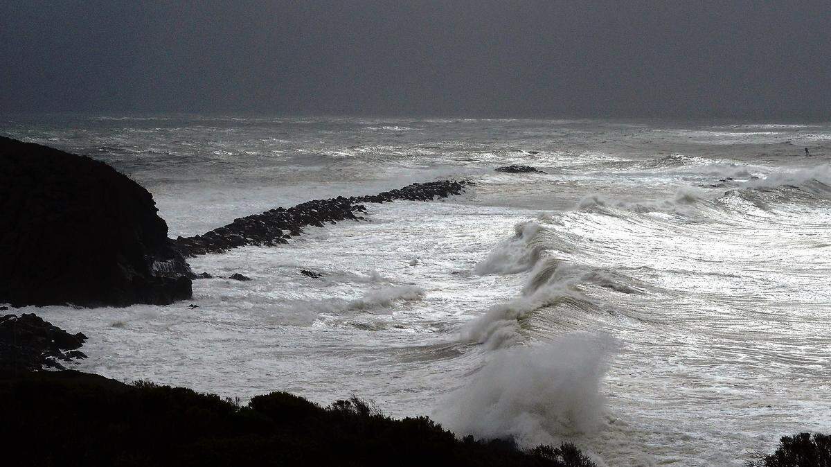
Surf report
A 3- to 5-foot westerly (275-degree deep-water) swell (with an 8- to 11-second period) is forecast along our coastline through Tuesday morning.
Increasing southerly winds will generate 5- to 7-foot southerly (190-degree shallow-water) seas (with a 4- to 6-second period) Tuesday afternoon, building to 9 to 11 feet with the same period Tuesday night through Wednesday.
An 11- to 13-foot southwesterly (245-degree deep-water) sea and swell (with a 5- to 15-second period) is forecast on Christmas through Friday, decreasing next weekend.
Seawater temperatures will range between 58 and 60 degrees through next Saturday.
On this date in weather history, Dec. 21
1964: A great warm surge from the Pacific Ocean across Oregon and northern California brought torrential rains on a deep snow cover resulting in floods. (David Ludlum)
2010: Copious amounts of rain fell over the Central Coast with Rocky Butte receiving over 11 inches of precipitation and many spots along the Central Coast receiving between 6 and 8 inches of rain including Diablo Canyon with nearly 7 inches. This asw the highest three-day total since March of 1995 at the Diablo Canyon Power Plant.
2020: A once-in-a-lifetime event happened with the conjunction of Jupiter and Saturn that appeared as a single “star.” The two planets appeared low in the southwest in the hour after sunset.
This week’s temperatures
LOWS AND HIGHS, PASO ROBLES
SUNDAY: 51, 62
MONDAY: 51, 63
TUESDAY: 48, 62
WEDNESDAY: 48, 59
THURSDAY: 48, 57
FRIDAY: 45, 55
SATURDAY: 40, 58
SUNDAY: 39, 62
LOWS AND HIGHS, SAN LUIS OBISPO AND COASTAL VALLEYS
SUNDAY: 56, 67
MONDAY: 56, 65
TUESDAY: 54, 65
WEDNESDAY: 54, 61
THURSDAY: 54, 59
FRIDAY: 49, 58
SATURDAY: 47, 61
SUNDAY: 52, 63
John Lindsey is a retired PG&E marine meteorologist. Email him at JohnLindseyLosOsos@gmail.com or follow him on X @PGE_John.